GeoRadar Uncovers Hidden WWII Bunkers Beneath London Streets Using Advanced GPR Utility Mapping PAS 128 Survey Standards
Geo-Radar Ltd Discovers Hidden WWII Bunkers Beneath London Pavement Using GPR and PAS 128 Survey Standards
GPR technology, we identified a hidden wartime bunker beneath a London pavement. It’s a powerful reminder of how much lies beneath our feet—and how vital accurate subsurface mapping really is.””
LONDON, LONDON, UNITED KINGDOM, June 24, 2025 /EINPresswire.com/ -- In the heart of London’s historic landscape, Geo-Radar Ltd has made a remarkable discovery beneath the city’s pavements: underground voids leading to forgotten WWII bunkers, hidden in plain sight for over 80 years. Using state-of-the-art Ground Penetrating Radar (GPR) and PAS 128-compliant utility mapping techniques, Geo-Radar is not only ensuring safer excavations—but also unearthing fragments of wartime history buried beneath the capital’s busy streets. https://geo-radar.co.uk/— David Green
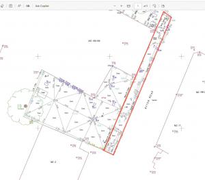
The project began as part of a routine GPR utility survey to identify subsurface hazards under a London footway prior to essential street works. However, the high-resolution scans revealed something extraordinary: a large, structured void, prompting further investigation. https://geo-radar.co.uk/gpr-surveys-southampton
🛰 Precision Meets the Past
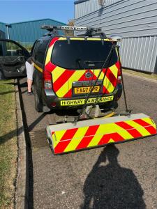
Utilising Leica DS2000 GPR systems and Trimble GNSS technology, Geo-Radar surveyors mapped the anomaly in real-time, capturing its scale, structure, and depth. The shape and dimensions closely matched wartime-era civil defence shelters—specifically air raid bunkers constructed beneath strategic city zones during World War II.
“What began as a utility risk survey quickly became a journey into history,” said David Green, Senior GPR Surveyor at Geo-Radar Ltd. “By applying PAS 128 methodology, we were able to verify the void’s location, size and alignment without disturbing a single paving slab. The precision of the data pointed to an intact wartime bunker—still hidden beneath the surface.”
🔍 PAS 128: The Survey Standard That Changed the Game https://geo-radar.co.uk/gpr-surveys-horsham
Geo-Radar’s use of PAS 128:2022 guidelines—the gold standard for underground utility detection in the UK—was key to identifying the void accurately and safely. This structured approach involves:
Desktop utility record searches (Type D) https://geo-radar.co.uk/
Site reconnaissance (Type C)
Non-invasive detection (Type B) using GPR and EML
Post-survey data validation and classification
In this case, the team performed a Type B survey with a B4 confidence level, combining GPR with electromagnetic locators and digital mapping tools. The result: a high-confidence detection of non-metallic underground features, such as voids or reinforced concrete shelters.
“PAS 128 doesn’t just help us find utilities—it helps us rule out risks, map voids, and avoid surprises,” added Green. “In this case, it helped us uncover a piece of London’s wartime infrastructure.”
🧱 What Lies Beneath London?
London’s streets hide more than just gas pipes and telecom cables. From old cellar voids and disused tunnels to bomb shelters, cisterns, and forgotten infrastructure, the underground landscape is a patchwork of the city’s past. Discovering buried voids in densely populated areas isn’t uncommon—but verifying their purpose and ensuring safety requires expertise.
Geo-Radar’s survey was conducted in a high-footfall pedestrian zone where safe excavation planning was essential. Had the void gone undetected, roadworks or construction may have led to structural collapse or worker injury.
“This is why non-intrusive GPR surveying is essential—not just for asset protection, but for public safety,” said a Geo-Radar project manager. “Our role is to see what others can’t, so that cities can grow without compromising what lies beneath.” https://geo-radar.co.uk/utility-surveys-berkshire
📐 Mapping the Future with GPR
With over a decade of experience in utility detection, void mapping, and sub-surface imaging, Geo-Radar Ltd serves engineering firms, local authorities, transport agencies, and heritage consultants across the UK. https://geo-radar.co.uk/gpr-utility-survey-surrey
Key services include:
PAS 128 Utility Surveys (Types B, C, D)
Void Detection & Mapping
3D GPR Imaging & Geophysical Interpretation https://geo-radar.co.uk/
Topographical & Measured Building Surveys
Safe Dig Plans & CAD Drawings
Heritage-Sensitive Subsurface Investigations
Whether working on EV charging site prep, smart city infrastructure, or emergency void detection, Geo-Radar delivers precision data that supports informed decisions and safer construction.
🕰 A Moment of History, Preserved Through Technology
The discovery of the WWII bunker was not only logged for safety, but also reported to the local heritage authority for review. In collaboration with structural engineers, the void’s integrity was assessed and stabilised—ensuring the site remained safe for ongoing works without damaging its historic value.
https://geo-radar.co.uk/utility-surveyors-pas128
Geo-Radar continues to work with stakeholders to map additional anomalies in the surrounding area, potentially uncovering more hidden wartime remnants.
“It’s an honour to bring history to the surface through modern technology,” said Green. “We don’t just locate utilities—we help preserve legacies.”
🧭 About Geo-Radar Ltd
Based in the UK and serving clients nationwide, Geo-Radar Ltd specialises in non-intrusive subsurface investigation, offering high-accuracy utility and void detection services across construction, infrastructure, and heritage sectors. Fully PAS 128 compliant and equipped with the latest GPR and GNSS technology, Geo-Radar helps clients build with confidence—above ground and below it. https://geo-radar.co.uk/utility-surveys-hampshire
📣 Contact Information
Geo-Radar Ltd
📍 London, UK
🌐 www.geo-radar.co.uk
📞 01483 429385 - 0208 1111 385
📧 info@geo-radar.co.uk
📱 LinkedIn: @GeoRadarLtd
🔖 Tags & Hashtags
#GeoRadar #PAS128 #GPRsurvey #utilitymapping #voiddetection #WWIIBunker #subsurfaceimaging #LondonHistory #nonintrusivesurvey #safeexcavation
Mike Brett
Geo-Radar
email us here
Legal Disclaimer:
EIN Presswire provides this news content "as is" without warranty of any kind. We do not accept any responsibility or liability for the accuracy, content, images, videos, licenses, completeness, legality, or reliability of the information contained in this article. If you have any complaints or copyright issues related to this article, kindly contact the author above.


